places Categories: Attractions and Mountainsplaces Tags: Mountain peaks in Pakistan
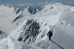
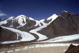
The area is quite isolated from Taliban areas. Moreover, Wakan is populated by Ismaili people that are in general against Taliban. Biggest threat is that you will be looted by local service provider. But we will get to it later. Well, that not only threat, that certain. Compare to standard 7k peaks where you can get nice service in BC you will be facing some more challenges. First and biggest challenge is logistic. Second is security. A yes, and actually last, but not least problem will be climbing the peak. Before getting to Afghanistan There are several things that you should not forget. First are VISAs. Remember that you would like to return back to the Tajikistan, thus you will need double entry to avoid ending stuck in Afghanistan. Second, beside your good climbing gear that you can rent in Afghanistan you will need to get propane-butane mix. And this could be a problem as it canbe carried in plane and it not easy to get in Dushanbe.Noshaq is the highest peak in Afghanistan and the second highest peak in the Hindu Kush Range (after Tirich Mir) at 7,492 m (24,580 ft). It lies on the border between Badakhshan Province in Afghanistan and Chitral District, , and is the world’s westernmost 7,000 meter massif.Noshaq was first climbed by a Japanese expedition in 1960 led by Professor Sakato. Other members of the expedition were Goro Iwatsabo and Toshiaki Sakai. The climb followed the normal Pakistan approach, the southeast ridge from the Qadzi Deh Glacier. The normal Afghanistan approach route is by the west ridge. The first winter ascent was in 1973 by Tadeusz Piotrowski and Andrzej Zawada, members of a Polish expedition, via the north face. It was the world first winter climb of any 7000m peak.Only the main peak and Noshaq West (7250m) are on the Afghanistan-Pakistan border (the Durand Line), a watershed divide. The other peaks of this massif lie well within Pakistan and are easily accessible from Chitral, 64 km away.
No Records Found
Sorry, no records were found. Please adjust your search criteria and try again.
Google Map Not Loaded
Sorry, unable to load Google Maps API.
-
- Pakistan
Pakistan
Pakistan
Pakistan -
This is a chain of peaks. Tirich Mir (Main) at 7,708m/25,288ft, is the highest peak in whole of the Hindukush range. The nearby glacier also has the same name (Tirich). The other nearby glaciers are North Barum, upper and lower Tirichs. The traditional route to the peak passes through Chitral – Reshun and Khosht-Drassan- Zani pass- Shagram and Shaikh Naik. Read more...
-
Pakistan is a country close to our hearts…and for good reason. Home to some of the most spectacular mountain scenery in the world, thriving cities, colourful markets and warm hospitality, a trip to this part of the world is bound to excite even the worldliest travellers. Having run trips here for more than a decade, we understand the political complexities Read more...
-
Chogolisa is a mountain in the Karakoram region of Pakistan. It lies near the Baltoro Glacier in the Concordia region which is home to some of the highest peaks of the world. Chogolisa has several peaks, the highest on the SW face (Chogolisa I) rises to 7,668 metres (25,157 ft). The second highest at 7,654 metres on the NE side (Chogolisa II) is the one named Bride Peak by Martin Conway in 1892 Read more...
-
Natural vegetation comprises forests, shrubs and grasses, and is determined by climatic conditions and soil types. The climate of Pakistan is too dry for forests, except in the northern hilly and sub-montane belts. Soil formation on the hill slopes is a prerequisite for forest growth, but human practices in these areas have contributed to erosion, rather than to soil formation. Read more...
-
Naltar Peak is a mountain in Naltar Valley in the Gilgit District of Gilgit-Baltistan, Pakistan. It lies to the southeast of Mehrbani Peak (5,639 m). Naltar village at 2800m has an army ski-training resort and is a good place to chill out and take a short easy trek around the valley. It is also starting point for two longer treks, Read more...
-