places Category: Valleys
The Tirah also spells as Terah, Tira, Tera region, also called the Tirah Valley , is located in Khyber, Kurram and Orakzai agencies in the Khyber Pakhtunkhwa province of Pakistan (33.73N 71.01E), while its smaller part straddles the border to the north lying in Nangarhar Province, Afghanistan. Tirah lies between the Khyber Pass and the Khanki Valley. It is inhabited by the Afridi, Orakzai and Shinwari tribes of Pashtuns
The population is rural, while Bagh Malikdinkhel, located in Maidan Tirah, is the traditional meeting place for Afridi jirgas or assemblies.
Lying close to the Pak-Afghan border and difficult terrain, control of Tirah for the government of Pakistan has been difficult. In 2003, for the first time since the independence of Pakistan, Army troops entered the Tirah valley.
It is also an area where the government has been trying to cut down on poppy cultivation. the dominant ethnic group here are the Pashtuns. There are minority communities of referred to as Hamsaya (protected peoples) such as the Sikh community who are mainly involved in trading and other professions
The Rajputs attacked the former and the latter were assailed by Ghairat Khan’s own troops, but the Mughal forces were repulsed with great loss. Six years later, however, Muzaffar Khan, son of Khwaja Abdul Hasan, then Sibahddr of Kabul, marched against Ihdad by the Sugawand pass and Gardez, and after five or six months’ fighting Ihdad was shot and his head sent to Jahangir. His followers then took refuge in the Lowaghar; and subsequently Abdul Kadir, Ihdad’s son, and his widow Alai, returned to Tirah. The death of Jahangir in 1627 was the signal for a general rising of the Pashtuns against the Mughal domination. Muzaffar Khan was attacked on his way from Peshawar to Kabul, and severely handled by the Orakzai and Afridis, while Abdul Kadir attacked Peshawar, plundered the city, and invested the citadel
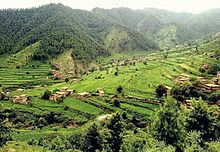
Tirah comprises an area of some six to seven hundred square miles and includes under this general name all the valleys lying round the source of the Bara River. The five chief valleys are Maidan, Rajgul, Waran, Bara and Mastura. Maidan, the summer home of the Afridis, lies close under the snow-bound ridges of the Safed Koh at an elevation of about 7,400 ft (2,300 m). It is an oval plain about seven to eight miles (13 km) long, and three or four wide, and slopes inwards towards the centre of its northern side, where all the drainage gathered from the four corners of the plain is shot into a narrow corkscrew outlet leading to the Bara Valley.
-


