places Category: Mountainsplaces Tags: Mountains in Gilgit Baltistan and Mountains In Pakistan
- The Makrong Chhish is and Barg in that Karakorum in that Pakistani Solar Territory Gilgit-Baltistan .
The Makrong Chhish is with a height of 6608 m and of the highest bars of the Spantik-Sosbun Bar . He lies up on the south side of the Hisparglets . Up the overpass Siet, 15 km north-north-east, the Kunyang Chhish boasts a height of 7852 m in Hispar Muztagh . The Makrong Chhish is flanked in the East by the West by the eastern West Glacier Glacier.Nah Süden is from the Makrong Chhish and Barggrat to a Gandesh Chhish (6346 m). The 14.37 km west-westerly landscape is superstructure with a height of 7027 m in the dominance point of view.
Overview
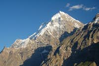
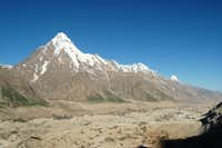
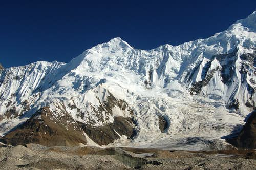
- Makrong Chhish is one of the most intimidating and impressive snow, rock and ice peaks that I know of in Pakistan. The mountain is the highest peak on the southern side of the Hispar glacier, the fifth longest glacier in Pakistan, and forms part of the Spantik-Sosbun group. The peak is heavily fortified in all directions with no easy lines to the summit. There are also significant objective dangers. The south face has numerous seracs that would make a direct route virtually impossible. The west face is a huge slab of rock that nobody has yet to attempt, largely because the rock is likely to be poor quality for the majority of the climb. The prominent southwest ridge could be climbed however this stops short on the south face which is lined with dangerous seracs below the summit. Only the Eastern aspect of the mountain has seen any attempts although the routes are certainly not straight-forward. The mountain remains unclimbed. It’s always difficult to know for certain what has been climbed in the Karakoram and what hasn’t as there have been a lot of illegal ascents over the years and many climbs haven’t been made public.
- Two expeditions have officially attempted the mountain to date. The first was by a British expedition in 1991 consisting of Steve Hillen, David Tyson, David Lister and Mike Pennington. Unfortunately it ended in disaster. Two attempts were made via the south face and eastern ridge. On the first attempt the party climbed to just under 6000m making two bivouacs on route before descending due to insufficient acclimatisation. The second attempt encountered difficulties as a result of crevasses having opened up since the first attempt. Having again reached the second bivouac at 11am on the second day the team were struck by an avalanche shortly after. Fortunately no one was hurt however it was decided to abandon the attempt. At 5pm while abseiling over two crevasses a snow stake pulled out and David Lister slid some 60 feet before coming to rest. This left Steve Hillen above the crevasses without a rope. Having front pointed down to the second crevasse he lost his footing after jumping across it. He began to slide. Dave Tyson who was below him tried to stop him only to become entangled and both slid down an avalanche runnel and over an ice cliff to their deaths. Their bodies were later recovered.
- The second attempt was made by another British team of Simon Yates and Steve Sustad in August/September 1996. It was plagued by unseasonably hot weather that made the route too dangerous to complete. Two attempts were made. The first via the Northeast face was thwarted at 5400m by unclimbable soft snow. The second, which approached tfrom the southeast flank reached 6400m before again being stopped by dangerous snow conditions and bad weather. Having opted to abort the attempt the pair were lucky get off the mountain safely after having been the victims of heavy rock fall in a narrow couloir that they were descending. Simon Yates has been quoted as saying that this as his closest encounter with disaster – quite a statement considering Simon Yates history!Mike Searle and Simon Yates climbed a peak in the area called Mikeron Chhish (6000m) but this is a different peak.
No Records Found
Sorry, no records were found. Please adjust your search criteria and try again.
Google Map Not Loaded
Sorry, unable to load Google Maps API.
-
- Makrong Chhish
Makrong Chhish
Gilgit Baltistan
Pakistan -
FEATUREDFeaturedHaigutum East is a minor snow peak on the south side of the Hispar Glacier, the fifth largest glacier in Pakistan. The peak forms part of the beautiful Bal Chhish range which is a dividing marker between the counties of Nagar and Baltistan. ‘Haigutum’ refers to the grazing area further east and is the last pasture on the southern side Read more...
-
FEATUREDFeaturedHispar Glacier (Urdu: ہسپر گلیشر) is a 49 km (30 mi) long glacier in the Karakoram Mountains of Gilgit–Baltistan, Pakistan which meets the 63 km (39 mi) long Biafo Glacier at the Hispar La (Pass) at an altitude of 5,128 m (16,824 ft) to create the world’s longest glacial system outside of the polar regions. Details This 100 km (62 mi) highway of ice connects two ancient mountain kingdoms, Nagar (immediately south of Hunza) in the west with Baltistan in the east. The extreme steepness of Read more...
-
FEATUREDFeaturedHussaini Glacier The Husseini Glacier is just on top of the Husseini village. The river flowing at the bottom of the picture just south of the village is the Hunza It is situated Nearby the most foamous Hussaini Hangging Bridge Known as the most dangrous Bridge in the world Hussaini Bridge is only one of the precarious rope Bridgees Read more...
-
FEATUREDFeaturedSpantik Peak is known by various names of its beauty and grandeur. The northwestern face on the Nagar side with its bright red color of golden pillar is called “Ghenish Chhish”, which in Brushaski (local language) means Golden Mountain. Ghinesh in Broshaski also means Queen. The peak is so majestic and beautiful that the local people call it Queen Mountain. Read more...
-
FEATUREDFeaturedDisteghil Sar is the highest mountain in the Hispar Muztagh, a subrange of the Karakoram mountain range, in Gilgit-Baltistan, which is part of the Kashmir region that is disputed by India and Pakistan. It is the 19th highest mountain on earth and the 7th highest peak in Pakistan. Destghil sar is a Wakhi language word, that means “above the inner ranch.” The mountain has an about 3 km long top ridge above 7400m with three Read more...
-