places Categories: Attractions and Valleysplaces Tags: Valleys in Gilgit Baltistan and Valleys in Pakistan
Kunar Valley Overview
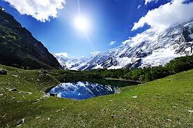
Kunar Valley is a valley in Afghanistan and Pakistan. In Afghanistan the length of the valley is almost entirely narrow with steep and rugged mountains on both sides. The center of the valley is occupied by the Kunar River flowing south where it joins the Kabul River. Subsistence farming and goat-herding are the extent of agriculture production on the valley floor and lower elevations. There are limited and small forested areas in some side valleys but more than 95% of the valley has been deforested. In limited areas at higher elevations there are sustained grassy mountain meadows. Overwhelmingly though the Kunar Valley is an arid, rocky, steep landscape with a fast-moving muddy river as its primary geographic feature.
Kunar (Pashto: کونړ, Persian: کنر) is one of the 34 provinces of Afghanistan, located in the northeastern part of the country. Its capital is Asadabad. It has a population of about 428,800.
The Kunar River is about 480 km long, located in north-western Pakistan and eastern Afghanistan. The Kunar river system is fed from melting glaciers and snow of the Hindu Kush mountains. The river rises in the far north of Chitral District in Pakistan. Downstream as far as Mastuj it is known as the Yarkhun River.
From there to its confluence with the Lutkho River just north of the important regional centre of Chitral it is called the Mastuj River.It is then called the Chitral River, before flowing south into the upper Kunar Valley in Afghanistan, where it is referred to as the Kunar River.
The Kunar River empties into the Kabul River just to the east of the city of Jalalabad in Afghanistan. The combined rivers then flow eastwards into Pakistan, joining the Indus River at the city centerock.
There are limited and small forested areas in some side valleys but more than 95% of the valley has been deforested. In limited areas at higher elevations there are sustained grassy mountain meadows. Overwhelmingly though the Kunar Valley is an arid, rocky, steep landscape with a fast-moving muddy river as its primary geographic feature.
No Records Found
Sorry, no records were found. Please adjust your search criteria and try again.
Google Map Not Loaded
Sorry, unable to load Google Maps API.
-
- watapur district ,Gilgit Baltistan,Pakistan
watapur district
Gilgit Baltistan
Pakistan -
Kharkoo Valley Overview Kharkoo Valley is a beautiful valley in Ghanche District (Gilgit-Baltistan Pakistan). Kharkoo Valley is located on the right bank of Shayok river between Daghoni and Saling and thus on the old connecting route between Khaplu and the other regions of Baltistan. Kharkoo belonged to the Kingdom of Khaplu before 1840 according to Tibet-encyclopaedia. Due to its longitude side location, Read more...
-
Khaplu Valley (Urdu and Balti) also spelled Khapalu, is a town that serves as the administrative capital of the Ghanche District of Gilgit-Baltistan, in northern Pakistan. Lying 103 km (64 mi) east of the town of Skardu, it was the second-largest kingdom in old Baltistan of the Yabgo dynasty. It guarded the trade route to Ladakh along the Shyok River. Read more...
-
FeaturedHaramosh (Urdu: ہراموش چوٹی; also known as Haramosh or Peak 58) is a mountain located in the Karakoram range of the Gilgit-Baltistan of Pakistan. Its height is also often given as 7,409m. Haramosh lies about 65 kilometres (40 mi) east of Gilgit, in the south-central region of the Rakaposhi-Haramosh Mountains, a subrange of the Karakoram range. It rises steeply above the north bank of the Indus River, a little ways upstream of its confluence with Read more...
-
The Haramosh Pass connects the Haramosh Glacier with Chogo Lungma glacier which lies in the North East. Spantik Peak Base Camp is a popular playground for mountaineers attempting their first 7,000-meter peak in Karakoram. It is surrounded by Laila Peak (6986m), Mani peak (6685m) and the Haramosh Peak (7409mIt is also known as Golden Peak & Ghenish Chhish. We undertake a 12-day Read more...
-
FeaturedKutwal Lake is a high-altitude lake located in the Haramosh valley of Gilgit district, in Gilgit-Baltistan, Pakistan. The valley of Haramosh is about 60 miles to the east of the district capital, Gilgit. The lake is surrounded by several high mountains, including Haramosh Peak, Laila Peak and Dobani Peak Read more...
-