places Category: Valleysplaces Tags: GhoomloPk, Valleys in Khyber Pakhtunkhwa, and Valleys in Pakistan
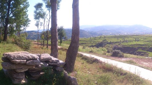
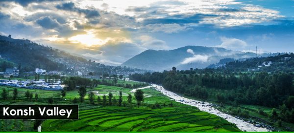
The Konsh Valley is located on the extreme northern borders of the Mansehra district of Khyber-Pakhtunkhwa province of Pakistan. The town of Battal is considered to be the headquarters of the valley. The Silk Route, also known as the Karakoram highway, passes through it leading to Gilgit. Towns, like Battal, and structures in the area, were severely damaged by the 2005 Kashmir earthquake. Konsh Valley, located in northwest Mansehra, like many other areas in the district, suffered severe damage. However, it has not received adequate attention compared to the other affected valleys in Mansehra. Konsh Valley has a total area of 23500 hectares. The altitude varies from 1067 meters at Ichhrian to 2911 meters at Bahishti Sar. The valley is inhabited by more than 76,000 people, made up of three main trips: Sayyed, Swati, and Gujars, reside in the area. Union Councils (UCs) are the main units of administration and have elected memberships. Maintenance of law and order and revenue collection are the major functions of the district government. Line agencies are represented at the district level and below. Livelihoods in Konsh are based primarily on livestock, rangelands and forest, and off-farm incomes. An average household keeps one or two buffalos, cows/oxen, some goats, and sheep. Livestock provides milk products and animal draft power and also serves as a form of savings. The fodder shortage is highest between January and April. The average farm is small and income from crop production is secondary to most households. Maize is the predominant crop. Wheat and potatoes are also grown, and some vegetables, where water is not a constraint. Most of the fields are terraced, but cropping on un-terraced slopes is also common, and causes accelerated soil erosion. There is potential for increased production of off-season vegetables, fruits, and fodder crops. The earthquake has had multiple effects on livelihoods, and subsequent aftershocks, torrential rains, flooding, and mudslides compounded the impact. The initial focus on relief and rebuilding rendered all economic activity to a minimum. Men were reluctant to leave their wives and daughters alone in camps while they found work, and migrant casual laborers returned home to assist families. Those who rely on remittances are buffering the impact. Also, village shopkeepers have not only stopped providing credit, but they have also been unable to provide food and non-food items. Poor and very poor households, typically reliant on local shopkeepers, have suffered immensely.
No Records Found
Sorry, no records were found. Please adjust your search criteria and try again.
Google Map Not Loaded
Sorry, unable to load Google Maps API.
-
- Mansehra District Khyber PakhtunkhwaPakistan
Mansehra
Khyber Pakhtunkhwa
Pakistan -
FEATUREDFeaturedKaghan Valley is an alpine-climate valley in Mansehra District of the Khyber Pakhtunkhwa Province of Pakistan. The tourists from across the country come to visit this place. The valley extends 155 kilometres (96 mi), rising from an elevation of 2,134 feet (650 m) to its highest point, the Babusar Pass, at 13,690 feet (4,170 m). Landslides caused by the devastating 2005 Read more...
-
FEATUREDFeaturedSiran Valley, is a little-known valley, situated in Mansehra District, Khyber-Pakhtunkhwa, Pakistan. Like the neighbouring areas, this valley also suffered greatly from the earthquake which hit the region on 8 October 2005 The valley gets its name from the River Siran which flows through it. The valley was earlier known as Bhogarmang valley getting its name from village Bhogarmang centrally Read more...
-
-
FEATUREDFeaturedBattagram Valley is a valley in Battagram District, which is located in Khyber Pakhtunkhwa, formerly known as North-West Frontier Province, northern Pakistan. Read more...
-
FEATUREDFeaturedAllai Valley is a valley in Battagram District of Khyber-Pakhtunkhwa, Pakistan. Read more...
-