places Category: Valleys
Siran Valley, is a little-known valley, situated in Mansehra District, Khyber-Pakhtunkhwa, Pakistan. Like the neighbouring areas, this valley also suffered greatly from the earthquake which hit the region on 8 October 2005
The valley gets its name from the River Siran which flows through it. The valley was earlier known as Bhogarmang valley getting its name from village Bhogarmang centrally situated in the valley. The name was later changed to Siran Valley by some literature pieces and adopted by later scripture as a reference. Khan khudad Khan of Bhogarmang was Minister of Health for both East and West Pakistan from 1952 to 1955. Sarfaraz Khan of Bhogarmang was one of the big landlords of the valley. Some Well Known people of this valley are Zardad Khan Swati from Bhogarmang a person who is known for his contribution to the Development of the valley and all the local connecting villages around the Siran Valley his Son Masood Nasir khan Advocate (Babar khan) Ex Nazim Bhogarmang Was Awarded by NDMA (National Disaster Management Authority) for his Day Night efforts and his Volunteer Works during the 8th October Earthquake and many Infrastructure projects. Riaz khan of Bhogarmang a well known Name of the Valley and he has served as Member parliament, Mohd. Afzal Khan a.k.a Saaen khan Bhogarmang, Aurangzeb Khan Bhogarmang, Jehanzeb Khan Bhogarmang, Sajjad khan Bhogarmang, haqnawaz khan sachan, shezada ghustasup khan Sum and naseem khan dariahal, Arslan Khan, Hassan Sajjad Khan, Moon Khan and local celebrities Waheed Khan(PPP), and Salahuddin aka “Chan” Khan(PTI)
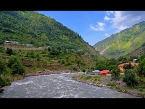
The Siran river is originates from the Mandagucha Glacier and merges into the Indus River. The Siran issues from Panjool and flows through the western plain of Pakhli. Two canals have been taken out from the Siran river, the upper Siran canal at Dharial and lower Siran canal at Shinkiari. From Pakhli the Siran runs into the Tanawal hills and joins the Indus at Tarbela in the north west. Its total course is between 70 and 80 miles, and it irrigates 6,273 acres of land
-


