places Category: Valleysplaces Tags: Beautiful Valley in gilgit baltistan and Beautiful Valley in pakistan
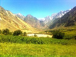
- Stak Valley (Urdu: استک نالہ, Balti: སྟཀ ནལ་) is a valley in the Roundu Subdivision of District Skardu, Gilgit-Balitistan, Pakistan. The valley is on the right bank of the Indus River, Pakistan’s longest river, between Skardu and Giligit city. The valley is the biggest valley in term of area and population in Roundu subdivision. The valley has been one of the very important regions of the area in term of in history and of geological formation as well.
Geography
- Stak Valley is situated in the middle of Skardu and Gilgit city on the right bank of the Indus River and Gilgit-Skardu Road. In the east of the Stak Valley lies the Askore valley and Thwar Valley. In the west are the Tooklano and Chamachoo. In the south there is Indus River and Ganji Valley just opposite to the Stak valley across the Indus river. In the north and northwest there is Haramosh and Kutia Glacier and likewise in the northeast the Goropha galacier.The prominent landmarks around the Stak valley are: Kutia Lungma Glacier, Goropha Glacier (which joins the Chogo Lungma Glacier), Haramosh Peak (7,397 m, 24,270 ft), Pharabar Peak (60,321 m 20,740 ft), Stak-La (Stak Mountain Pass 4,601 m, 15,491 ft) and some other peaks (Shinka, Mashika, Korang Kar) which are about 6,000 m (20,000 ft). The Stak River originates from the Stak-La and joins by Goropha, Kutia and Tooklano Streams and falls in Indus River after completing a course of about 30 km. The Stak River bisects the Stak Valley into two halves. One half starts from Rgialmokaza to Skangbudas and the other side starts from Khirzang to Tookla. Tookla is the last village of Stak, which is partly destroyed by a massive flood in 1999 which caused a huge destruction in the area, destroying the Gamba Tookla completely and Gongma Tookla partially. According to Geologists most of the villages are formed by the moraines, although the valley is one of the fertile valleys of the Roundu Subdivision.
- Stak Valley (Urdu: استک نالہ, Balti: སྟཀ ནལ་) is a valley in the Roundu Subdivision of District Skardu, Gilgit-Balitistan, Pakistan. The valley is on the right bank of the Indus River, Pakistan’s longest river, between Skardu and Giligit city. The valley is the biggest valley in term of area and population in Roundu subdivision. The valley has been one of the very important regions of the area in term of in history and of geological formation as well.
No Records Found
Sorry, no records were found. Please adjust your search criteria and try again.
Google Map Not Loaded
Sorry, unable to load Google Maps API.
-
- Stak La
Stak La
Gilgit Baltistan
Pakistan -
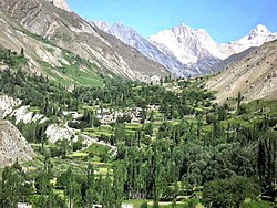
FEATUREDFeaturedTurmik is a valley in the Karakorum mountain ranges in the Skardu District of Gilgit-Baltistan, Pakistan. The valley has its source at the Stak-la and Basha valley lies to its east and Stak Valley to its west. The valley is the second largest valley in term of population and area, Stak Valley being the first, in the Roundu Subdivision Read more...
-
Khaplu Valley (Urdu and Balti) also spelled Khapalu, is a town that serves as the administrative capital of the Ghanche District of Gilgit-Baltistan, in northern Pakistan. Lying 103 km (64 mi) east of the town of Skardu, it was the second-largest kingdom in old Baltistan of the Yabgo dynasty. It guarded the trade route to Ladakh along the Shyok River. Read more...
-
Kharkoo Valley Overview Kharkoo Valley is a beautiful valley in Ghanche District (Gilgit-Baltistan Pakistan). Kharkoo Valley is located on the right bank of Shayok river between Daghoni and Saling and thus on the old connecting route between Khaplu and the other regions of Baltistan. Kharkoo belonged to the Kingdom of Khaplu before 1840 according to Tibet-encyclopaedia. Due to its longitude side location, Read more...
-
Kunar Valley Overview Kunar Valley is a valley in Afghanistan and Pakistan. In Afghanistan the length of the valley is almost entirely narrow with steep and rugged mountains on both sides. The center of the valley is occupied by the Kunar River flowing south where it joins the Kabul River. Subsistence farming and goat-herding are the extent of agriculture production Read more...
-
FEATUREDFeaturedHaramosh (Urdu: ہراموش چوٹی; also known as Haramosh or Peak 58) is a mountain located in the Karakoram range of the Gilgit-Baltistan of Pakistan. Its height is also often given as 7,409m. Haramosh lies about 65 kilometres (40 mi) east of Gilgit, in the south-central region of the Rakaposhi-Haramosh Mountains, a subrange of the Karakoram range. It rises steeply above the north bank of the Indus River, a little ways upstream of its confluence with Read more...
-