places Categories: Attractions and Mountainsplaces Tags: Attraction Mountains, Mountain in swat, Mountains In Kpk, and Mountains In Pakistan
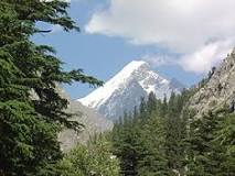
Falak Sar also known as Falak Sair) is the highest mountain peak in Ushu Valley of Swat, Pakistan at an elevation of 5,918 metres (19,416 ft), it is considered the highest peak of the Swat district in the Hindu Kush mountains range, followed by Mankial mountain peak.
This mountain was climbed for the first time by W.K.A Berry and C.H. Tyndale-Biscoe of New Zealand in 1957 from its North ridge. The second ascent was made by Dr. Wolf Gang Stephen who also climbed Distaghil Sar and Malika Parbat.. Carlo Pinelli attempted another peak in the Hindu Raj which is the only 6000 of this part of Hindu Kush. They named it Maingol Sar.Similarly, another ascent was made by a Japanese expedition from Yamaguchi University was composed of Yoshiyuki Nagahiro and Toshiyuki Akiyama. After traveling by car from Peshawar through Saidu Sharif, capital of Swat, to Matiltan, they continued on and headed up the Falak Sar valley, where at 11,000 feet on August 15 they established Base Camp. On August 20 they climbed Falak Sar (19,417 feet), which has had numerous previous ascents. After returning to Matiltan, they went through Kalam to the Amagal valley to an advanced base at 12,000 feet. They ascended the east side above their advanced base and reached a small peak which was called Maga Sar by the natives. They found no Miangul Sar (19,554 feet) but there was a peak called Par (c. 18,000 feet) in the position assigned the former peak
No Records Found
Sorry, no records were found. Please adjust your search criteria and try again.
Google Map Not Loaded
Sorry, unable to load Google Maps API.
-
- Ushu Valley,Ushu Valley,Pakistan
Ushu Valley
Ushu Valley
Pakistan -
The beautiful valley of Kalam is situated in the upper northern portion of Swat valley in Khyber Pakhtunkhwa. Kalam is located at an altitude of 2000 meter. The valley of Kalam is filled up with natural beauty. Beautiful and eye-catching views are spread all over the valley of Kalam. Beautiful Kalam valley is just 99KM away from Mingora. Sawat river Read more...
-
Khānko Dhand is a lake and is located in North-West Frontier Province, Pakistan. The estimate terrain elevation above seal level is 3889 metres. Variant forms of spelling for Khānko Dhand or in other languages: Khānko Dhand (en), Khanko Dhand, Khānko Dhand. Read more...
-
Map driving distance from Swat to Mankial Sar is 83 Km … Swat to Khyber Pakhtunkhwa, Pakistan Travel Time from Swat to Khyber Pakhtunkhwa, Pakistan Swat … Read more...
-
Shetāngud Dhand is a lake and is located in North-West Frontier Province, Pakistan. The estimate terrain elevation above seal level is 4066 metres. Variant forms of spelling for Shetāngud Dhand Read more...
-
The name Izmis means caves in Kohistani and as the lake is surrounded by several natural caves, the people have named the lake after these caves. Izmis Lake is located to the North-east of Utror valley at a high altitude above the tree line. A small jeep-able link road from Utror leads towards the location of the lake which ends Read more...
-